Cemented cable ducting on the M80 rail bridge looking north
I wanted to see the Camp Road Level Crossing Removal done as per the plans presented and discussed at the community consultations. I thought this was a fairly straight forward level Crossing Removal. All they had to do was ensure facility for easily adding a shared use path (bikepath), a station at Campbellfield, and facility to upgrade to dual track.
Of course it would have been much cheaper and more efficient to upgrade to dual track during the Level Crossing Removal and do all the earth removal for the station at the same time. As well as providing a shared use path.
But it seems after the community consultation the Crossing Removal plans were changed. There is no provision for a shared use path under Camp Road whatsoever.
I visited the site on February 6 and the John Holland workers said they would be enclosing and locking off the access track that runs from Camp Road beside the railway line, across the rail bridge over the M80 to stop any pedestrian, joggers or cyclists along this track.
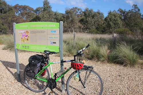
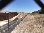
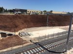
Even worse. The railway bridge over the M80 ring road has single track, provision for a second track and a reasonably wide pedestrian path space. The Level Crossing Removal chose to use the pedestrian pathway for electrical conduits, cementing them in, leaving a narrow path, perhaps 90 cm wide to walk over the bridge. This is most unsatisfactory. They have made extending the Upfield Path to Upfield very expensive, if not impossible, with these works.
Let’s get this straight. The Level Crossing Removal at Camp Road only benefits the drivers along this road, not the rail passengers on the Upfield line who were inconvenienced, or the people that were using the service track along the rail line and future users of a shared use path. The Level Crossing Removal appears to have actually made it more difficult to develop the Upfield shared use path in the Upfield Transport Corridor.
This is poor planning and implementation of a relatively straight forward level Crossing Removal. The planners and builders of yesteryear thoughtfully provided space for a shared use path on the M80 rail bridge, which the Level Crossing Removal Authority have utilised with no thought for future use. We have actually gone backwards with this infrastructure project…..except if you are a road user.
I was given an explicit undertaking by Kevin Devlin, CEO of the Level Crossing Removal Authority, in a letter he wrote dated 6 December 2017 as delegated from the Minister for Transport Jacinta Allen (PDF). These assurances included that the work was done to “easily accommodate future improvements to the rail line and surrounding infrastructure such as the bike path.”
Similarly, Devlin assured me that “LXRA is working closely with both Hume and Moreland Councils to ensure the current works deliver the best possible outcomes for the community within the scope of the project”.
I have raised this with Councillors from Moreland and Hume. The ones that have responded have not sounded impressed. Some of the outcomes have actually gone backwards, against Council policy and strategies for development of cycling infrastructure.
Here are some details:
- Sydney Road is an 8 lane road, expanding to 14 traffic lanes including for turning lanes at Camp Rd/Mahoneys Rd/Sydney Rd intersection at Campbellfield with a 70Km speed zone. I think it is most unsafe to cycle on Sydney Road at this location due to the high volume of traffic and traffic speed.
- VicRoads has not provided any safe alternative route for cyclists travelling north/south adjacent to or near Sydney Road. This function could be provided by the Upfield corridor and extension of the Upfield shared use path to Barry Road at Upfield.
- VICRoads has no plans to extend the Upfield path, despite requests from Moreland and Hume Councils.
- Please note that the residents of Campbellfield Heights have no backstreet route to access the shops at Campbellfield plaza. They have to come onto Sydney Road (or use the unformed footpath) to access the shops. While creation of the Upfield path would not resolve the difficulty of cycling from Campbellfield residential area to Campbellfield Plaza, it illuminates the problem that there is no safe route for cyclists.
- As there is no provision made for Upfield shared use path to go under Camp Road, the only other option is for it to go alongside the railway on the service track, then a pedestrian crossing across the 4 lanes and two cycles lanes on Camp Road. Putting in pedestrian crossing lights would seem to remove part of the advantage of the Level Crossing Removal in periodically holding up traffic. It would be a nightmare to cross without pedestrian crossing lights. I would be pleased to find out how else planners propose that a shared use path can be installed in an easy, efficient and cost effective manner at this point.
- The Level Crossing Removal Authority have used the space allocated for pedestrian/cyclist shared use on the rail bridge across the M80 ring road for electrical cabling ducts and cemented them into place. I would like to know how a shared use path can be installed easily and cost efficiently given the work undertaken by the Level Crossing Removal Authority in utilising this portion of the bridge seemingly ruining any prospect of it being used for a shared use path.
- Developing infrastructure with poor access at Merri Creek Reserve: Note that that the Victorian State Government committed $1.7 million to develop visitor infrastructure, including 6km of new bike and walking paths, at Merri Creek Park in Campbellfield (Merri Gorge) in February 2017. But we are still to see any commitment to build important bicycle shared use paths in Campbellfield: the extension of Merri Creek Trail and Extension of the Upfield bike path to Barry Road at Upfield.
- Melbourne is growing in population. Cycling infrastructure, as well as mass transit, needs to be expanded into the middle and outer suburbs to enable residents of these suburbs to choose to use recreational or commuter cycling which has positive emissions reduction and health benefits at a societal level. Extending the Upfield path could provide a convenient cycle commuter route for some Hume residents to Moreland and the city.
I did a site inspection of the Camp Road bridge and rail bridge across the M80 on February 6, 2018. I immediately reported the issue to the Level Crossing Removal Authority by phone, an email to Frank Maguire (MP for Broadmeadows) office, Samantha Ratnam as my legislative Council MP.
I am still waiting responses from the Level Crossing Removal Authority project team. I was told a member of the Level Crossing Removal Project team would get back to me within a week. There has been no response after 20 days.
I followed up my initial email to Frank Maguire MP (Broadmeadows) in person at his office on Friday 23 Feb, but other than acknowledgement that my issue has been registered I have received no further feedback from his office.
I am sure there is going to be more to this story…stay tuned.
Photos from site visit on February 6, 2018
-

-
Under the road bridge
-

-
Closeup of Level Crossing in the design plan
-

-
Cemented cable ducting on the M80 rail bridge looking north
-

-
Cemented cable ducting on the M80 rail bridge looking north
-

-
Cemented cable ducting on the M80 rail bridge looking south
-

-
service road on left and Camp Rd bridge
-

-
service road on left and Camp Rd bridge
-
-
Looking north from the road bridge
-
-
Campbellfield station from road bridge